Tracking the Elusive HM Dockyard Observatory
(also known as the Halifax Dockyard Observatory) Page 1
by Joel Zemel Copyright 2012-2015
ISBN #978-0-9684920-2-4
Page 1 Page 2
(also known as the Halifax Dockyard Observatory) Page 1
by Joel Zemel Copyright 2012-2015
ISBN #978-0-9684920-2-4
Page 1 Page 2
In August of 2011, my friend Jeanne Howell, Librarian for the Cambridge Military Library (now retired), was asked by a party at the Maritime Museum of the Atlantic for for information regarding the appearance of an observatory used to rate chronometers that may have existed at HMC Dockyard as early as the "Shannon/Chesapeake incident in the War of 1812. I was very interested in helping to track down any information that would lead to a drawing or a photograph of this building. Even though I was conducting research for my book on the legal proceedings following the 1917 Halifax Explosion at the time, I had developed a great interest in the general history of HMC Dockyard.
The literature on the subject is vague at best. There is a reference in an article by D. A. Story contained in the records of the Nova Scotia Historical Society, Vol. 22, "H.M. Naval Yard, Halifax, in the Early Sixties", p. 56. It contains the following passage:
"Just beyond this, on the right stood Observatory Hill, long since cut down to enable a drill ground for the sailors to be laid out, but which was in the early days surmounted by a wooden block house, known as Fort Coote, and later by an octagonal Observatory from which it took its name."
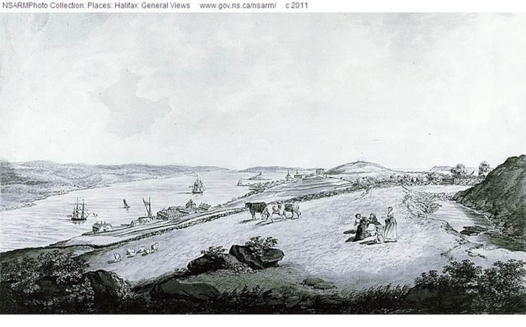
Below is a close-up of an engraving by Edward Hicks, View from Needham Hill, 1780 (NSARM/PANS). A representation of Fort Coote is seen on the left.
The literature on the subject is vague at best. There is a reference in an article by D. A. Story contained in the records of the Nova Scotia Historical Society, Vol. 22, "H.M. Naval Yard, Halifax, in the Early Sixties", p. 56. It contains the following passage:
"Just beyond this, on the right stood Observatory Hill, long since cut down to enable a drill ground for the sailors to be laid out, but which was in the early days surmounted by a wooden block house, known as Fort Coote, and later by an octagonal Observatory from which it took its name."
Below is a close-up of an engraving by Edward Hicks, View from Needham Hill, 1780 (NSARM/PANS). A representation of Fort Coote is seen on the left.
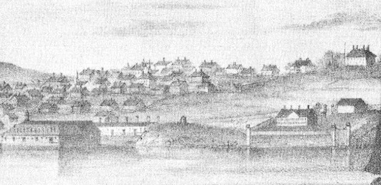
Fort Coote was torn down ca. 1800. A close-up from an 29 April 1801 drawing (below), View from Fort Needham near Halifax by George I. Parkyns shows an empty space where the fort had once stood.
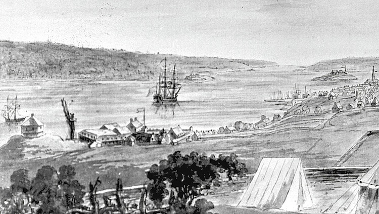
A close-up from a drawing by William Eagar published in 1839 entitled Halifax, From the Red Mill, Dartmouth, depicts a small building in what was the old Forte Coote location that resembles Story's description of the observatory. Though many will dispute the credibility of drawings and etchings, the structure's presence in this print cannot be ignored. Eagar lived and worked in Halifax. His works were reputed to be "views taken on the spot and on stone."
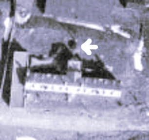
I discovered the photo below (ca. 1883) while searching through the photographic records of The Royal Engineers in Halifax on the Nova Scotia Archives and Management website. The roof on the small structure to the left in the image is similar in appearance to the rotating observatory roof designed by John Smeaton.
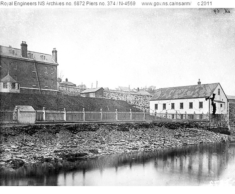
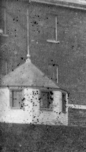
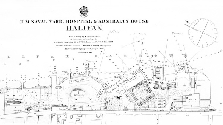
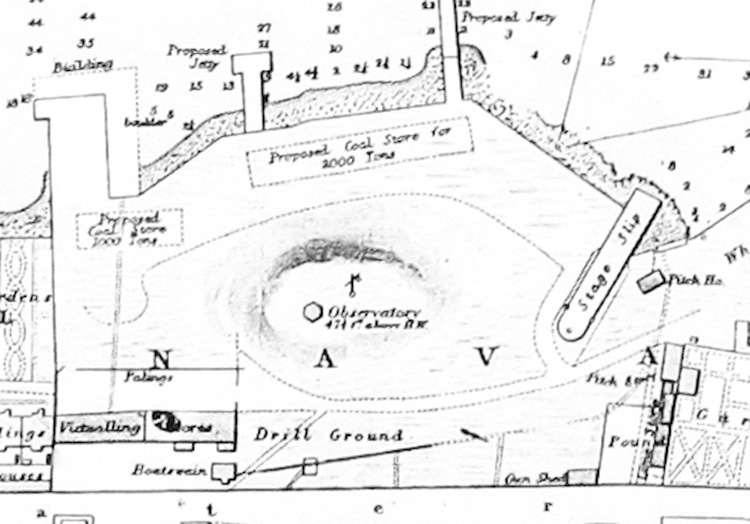
The fact that the building sat in front of the Naval Hospital (built in 1863) gave me reason enough to believe this was not the observatory. My research became stalled for a while until Jeanne let me know she had discovered an 1859 hydrographic map from a survey by W. A. Hendry that had been corrected to 1869 by Edward J. Powell. A copy of an earlier version of this map by Powell dated 1867 is housed at Maritime Command (MARCOM). The Powell maps show the observatory in the former location of old Fort Coote at 47 and half feet elevation as depicted in William Eagar's 1839 drawing. In the close-up (below), the observatory (in both maps) is hexagonal and not octagonal as one would expect. It is important to note that the site of the observatory is several hundred yards to the southeast of the Naval Hospital.
Powell's correction date on Hendry's hydrographic map suggests the observatory was extant as late as 1869. Due to a lack of corroborative documents or images, my suspicion is that the Dockyard Observatory was removed before this date. The hill on which Fort Coote and the Observatory were located was levelled by the Royal Engineers (1881-83) and removed (1884-85) by contractor Thomas Giles starting July 28, 1884 for the "Removal of observatory hill in Her Majesty's dockyard, Halifax, and depositing material on Intercolonial Railway lands."
In papers published by Curator of the Provincial Museum, Rev. David Honeyman in Transactions the Nova Scotian Institute of Natural Science, he described the hill as the remnant of a glacial drumlin. He also noted that running through the coarse clay and sand were many different types of large boulders including "enormous" quartzite masses; "the weight of one was estimated by Mr. Nolan [the superintendent] at 13 tons." The task of removal took nearly a year and three months to complete. Honeyman also wrote that "The hill disappeared finally, on November 4th, 1885, at 3:50 P.M., railway time; I watched its disappearance."
Close-up:
Beyond this discovery, continued research produced no substantial results, so I moved on to other things.
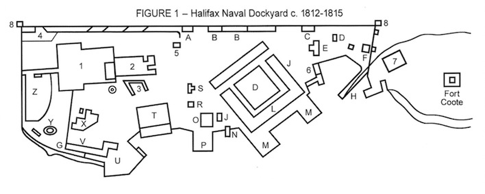
In November 2012, while at the MMA on an unrelated matter, I saw an exact model of the little spired building in the 1812 display case - as the authenticated Dockyard Observatory. I made an inquiry to Dan Conlin, the curator of the museum. According to Conlin, the MMA's acceptance of the notion that a model of the observatory be included in the exhibit was based on an 1839 copy by James MacKenzie of an 1815 map of the dockyard by John G. Toler obtained by the MMA. Indeed, this map shows an octagonal structure on Observatory Hill.
I obtained a copy from the Naval Museum of Halifax at MARCOM courtesy of Museum Director, Richard Sanderson. Clearly marked on the map is the following: Plan of Her Majesty's Careening Yard at Halifax, N. Scotia, Established in 1759. Surveyed & Planned by John G. Toler in May 1815, copied by James MacKenzie [sic], 1839, (Admiralty Library Pfo B 23).
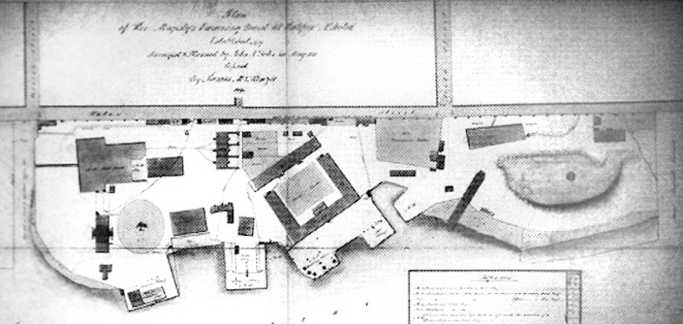
However, my subsequent research has lead me to conclude there is no substantive proof to warrant any reason to connect the small spired structure to the dockyard observatory. Furthermore, there is enough strong evidence to cast doubt on the notion the observatory was present in the dockyard as early as 1812-1815.
It would be impossible to verify unequivocally whether the observatory was in the dockyard in 1815 without having first viewed the original 1815 plan by John George Toler. The use of the words "copied" or "corrected" restrict the reliability of a plan only to the year in which it was drawn - let alone a span of 24 years. According to Garry Shutlak, Senior Archivist at PANS, without the words "True Copy" or "Record Copy" present, the plan is only relevant to the year in which it was copied. As well, there is no mention of the observatory in the Reference Panels.
This evidence renders the entire contents of the plan suspect. Furthermore, Edward J. Powell's hexagonal depiction of the observatory on the 1867 and 1869 corrected Hendry maps must be considered. Regardless, the MMA display is supposed to represent HMC Dockyard as it appeared in 1812-1813. Least of all, the presence of the observatory on an 1815 map is still not proof that it existed in previous years.
In the report Tracing the Built Form of HMC Dockyard, by Brent Raymond (1999, N. S. Museum Curatorial Report No. 88) there is no mention or illustration of an observatory with regard to an 1818 configuration of the dockyard, only a mention and representation of Fort Coote which had been razed approximately sixteen years earlier.
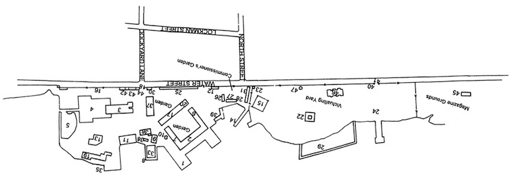
Also, this drawing by Philip Eisnor from "King George III's Naval Yard at Halifax" by John Green, Nautical Research Journal, Vol. 51, No. 2 Summer 2006, p. 84, shows a drawing and References regarding HMC Dockyard 1812-1815. Again, Fort Coote is shown even though it did not exist at the time.
In Nautical and Astronomical Tables: Compiled and Computed for Facilitating Operations in Navigational and Nautical Astronomy by Thomas Lynn (1827), the latitude and longitude of Halifax is listed on p. 48 with a variation.
In his June 2010 thesis, "The Expansion of British Naval Hydrographic Administration, 1808-1829," Adrian Webb, Archive Services Manager at United Kingdom Hydrographic Office, states the following:
"Similarly Parry was consulted over the question of supplying three chronometers to Rear Admiral Sir Charles Ogle at Halifax in 1828. The former also wrote to Bayfield in March 1829 informing him how two chronometers and a station pointer were being sent to him and that a receipt for them was required. All proving how, despite the transfer, the Hydrographer still had some involvement with the supply of chronometers."
Below is an excerpt from page 10 of The Nautical Magazine issue of March 1832. It refers to a survey of The Virgin Rocks in Newfoundland in July of 1829. There is no reference to an observatory in Halifax with regard to the determination of the readings.
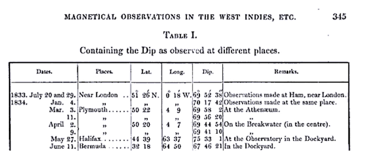
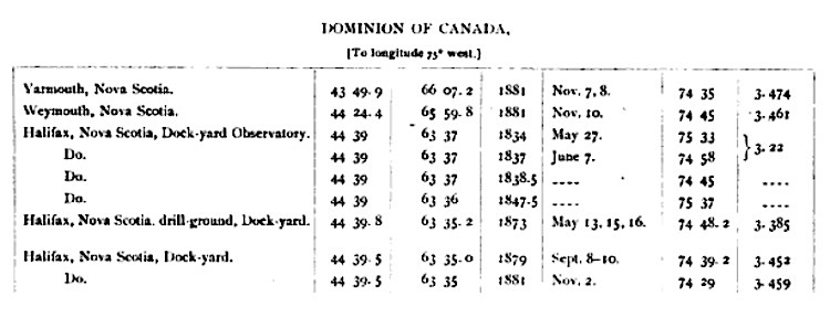
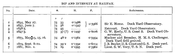
A 27 May 1834 reference to the Halifax Dockyard Observatory regarding the observations of Sir Everard Home is found on page 345 in Philosophical Transactions of the Royal Society of London, Vol. 128, Part 1, W. Bowyer and J. Nichols for Lockyer Davis, printer to the Royal Society, 1838. This exact date also appears in reports of the superintendent, U. S. Coast and Geodetic Surveys for June 1885 and 1895. This 1834 date is the earliest documented reference to the observatory I have been able to locate.
A very close examination of a contact print (PANS) of the sole photo of the spired building from the PANS Royal Engineers Collection reveals it to have been in very good condition and octagonal in shape; a fourth window is shown in a small section cropped out of the online version. Having this building in an 1812 display presupposes that 68 or so years later, the observatory was moved from its old Fort Coote location to the front of the Naval Hospital when Observatory Hill was levelled by the Royal Engineers. There is no logical reason and little evidence to support such a theory. In fact, the actual purpose of the spired building had nothing to do with that of an observatory.
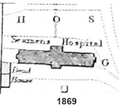
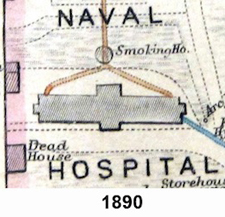
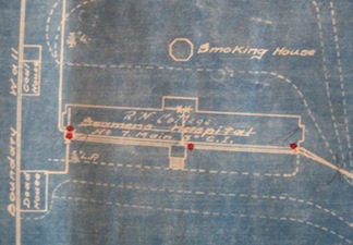
In his notes, PANS archivist Harry Piers (1870-1940) suggests this structure was a summer house [with a question mark]. Proof of this very close assessment can be found within two corrected W. A. Hendry maps housed at PANS. Although the structure is not shown on the corrected W. A. Hendry map of 1869, it is displayed and clearly labelled on the corrected Hendry maps of 1890 and 1893 as a Smoking Ho. [smoking house]; most likely built for and used recreationally by the hospital staff.
The maps from 1867, 1869, 1890 and 1893 were all based on the original 1859 W. A. Hendry survey map. Even though all maps are of the same scale: "Scale 200 ft. to an inch, or about 30 inches to a Sea Mile," the drawings of structures are slightly inconsistent. At this scale, accurate digital comparisons of structures cannot be carried out. For example, superimposing the observatory from the 1869 map in front of the Naval Hospital in 1890 would not yield reliable results regarding relative dimensions of the observatory compared to those of the smoking house because the hospitals themselves are not identical.
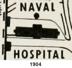
As seen below, the spired structure did not exist in 1869. However, the 1904 map shows the building was still standing. (from The Naval Service of Canada - Its Official History, Volume I, Origins and Early Years by Gilbert M. Tucker (1952 - authority of Minister of National Defence, Drawn from Works Office Plan No. XXIX, corrected to 1904). A 1910 water main blueprint of the Dockyard corrected to 1914 (MARCOM) clearly lists the building as the "Smoking House." A 1921 flyover image also shows the structure still intact.
In his notes, PANS archivist Harry Piers (1870-1940) suggests this structure was a summer house [with a question mark]. Proof of this very close assessment can be found within two corrected W. A. Hendry maps housed at PANS. Although the structure is not shown on the corrected W. A. Hendry map of 1869, it is displayed and clearly labelled on the corrected Hendry maps of 1890 and 1893 as a Smoking Ho. [smoking house]; most likely built for and used recreationally by the hospital staff.
The maps from 1867, 1869, 1890 and 1893 were all based on the original 1859 W. A. Hendry survey map. Even though all maps are of the same scale: "Scale 200 ft. to an inch, or about 30 inches to a Sea Mile," the drawings of structures are slightly inconsistent. At this scale, accurate digital comparisons of structures cannot be carried out. For example, superimposing the observatory from the 1869 map in front of the Naval Hospital in 1890 would not yield reliable results regarding relative dimensions of the observatory compared to those of the smoking house because the hospitals themselves are not identical.
As seen below, the spired structure did not exist in 1869. However, the 1904 map shows the building was still standing. (from The Naval Service of Canada - Its Official History, Volume I, Origins and Early Years by Gilbert M. Tucker (1952 - authority of Minister of National Defence, Drawn from Works Office Plan No. XXIX, corrected to 1904). A 1910 water main blueprint of the Dockyard corrected to 1914 (MARCOM) clearly lists the building as the "Smoking House." A 1921 flyover image also shows the structure still intact.
An extract from a very detailed 1827 map of Halifax and approaches by Lieutenant William Scarth Moorsom of the 52nd Light Infantry, obtained from the National Archives at Kew, also showed no signs of anything occupying the space atop the the hill but it did narrow down the timeline for the construction of the observatory on the knoll.
The best evidence available for an approximate construction date is the image below - provided by Richard Sanderson, Curator of the Maritime Command Museum in Halifax (MARCOM) - from an 1831 HM Dockyard Plan (National Maritime Museum, Greenwich, England, Negative Number A-5921). This image clearly shows an empty circular space (no number or corresponding description) where Fort Coote once stood (middle right). A slight berm is indicated around most of the circumference. The signature at the bottom right of the complete plan is difficult to make out on the xerox copy. However, it may have been that of the Royal Navy's architect, George Ledwell Taylor.
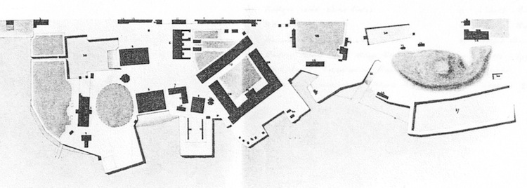
The best evidence available for an approximate construction date is the image below - provided by Richard Sanderson, Curator of the Maritime Command Museum in Halifax (MARCOM) - from an 1831 HM Dockyard Plan (National Maritime Museum, Greenwich, England, Negative Number A-5921). This image clearly shows an empty circular space (no number or corresponding description) where Fort Coote once stood (middle right). A slight berm is indicated around most of the circumference. The signature at the bottom right of the complete plan is difficult to make out on the xerox copy. However, it may have been that of the Royal Navy's architect, George Ledwell Taylor.
Therefore, based on the aforementioned documented 1834 references and the 1831 HMC Dockyard Plan, it follows that the HMC Dockyard Observatory most likely was constructed between the years 1831 and 1834.
A search through issues of The Nautical Magazine, 1832-1834, records of the Royal Engineers (1829 to 1836), as well as the (Naval) Yard Commissioner's letters and procurement records for the years 1829 to 1836 have, so far, displayed no direct references to the construction of the HMC Dockyard Observatory in Halifax. The available letters of Commanders-In-Chief, Ogle and Colpoys and Captain Superintendent Ussher (1829 through 1836) yielded no additional information. [However, as shown on Page 2, the search took a different turn once the forest became separated from the trees.]
A search through issues of The Nautical Magazine, 1832-1834, records of the Royal Engineers (1829 to 1836), as well as the (Naval) Yard Commissioner's letters and procurement records for the years 1829 to 1836 have, so far, displayed no direct references to the construction of the HMC Dockyard Observatory in Halifax. The available letters of Commanders-In-Chief, Ogle and Colpoys and Captain Superintendent Ussher (1829 through 1836) yielded no additional information. [However, as shown on Page 2, the search took a different turn once the forest became separated from the trees.]
* * *
The three issues in question:
1) Whether the spired structure in front of the Naval Hospital was the Dockyard Observatory.
2) Whether the Dockyard Observatory existed as early as 1815.
3) The physical appearance of the observatory itself.
Conclusions:
1) The spired building is specifically designated as a smoking house on the 1890 and 1893 corrected W. A. Hendry maps.
2) The photograph of the structure ca. 1883 shows the structure as fairly well-kept with a solid appearance.
3) That the structure sat in front of the Naval Hospital strongly indicates it was not the observatory.
4) If one were to accept Edward J. Powell's (1867 & 1869) hexagon shape for the observatory, the smoking house as it appears in the ca. 1883 photograph and on the 1890 map does not match that description.
5) The building sat in front of the Naval Hospital as late as 1921 (Below: December 1918). The fact it was still present years after the documented destruction of the observatory by the Royal Engineers, plus all of the preceding factors, constitutes a preponderance of evidence that the spired structure was not the observatory.
6) The MacKenzie plan copy does not prove the observatory was present in HMC Dockyard in the year 1815. The words "true copy" or "record copy" are not present and the description states it is is Her Majesty's (Victoria) not His Majesty's (George III) careening yard. Also, the respective Reference Tables of this plan and the 1831 George Ledwell Taylor plan show buildings which were not present in 1812-1819. The plans are so similar, it raises the possibility that McKenzie's was a copy of Taylor's original work. 7) Edward J. Powell's hexagon vs. James MacKenzie's octagon remains an anomaly and puts into question the accepted appearance of the actual observatory as the latter.
8) The Dockyard Plan from 1831 shows no structures in the area formerly occupied by Fort Coote.
All in all, the distinct lack of documentation as to the origins of both buildings indicates that much more research is required.
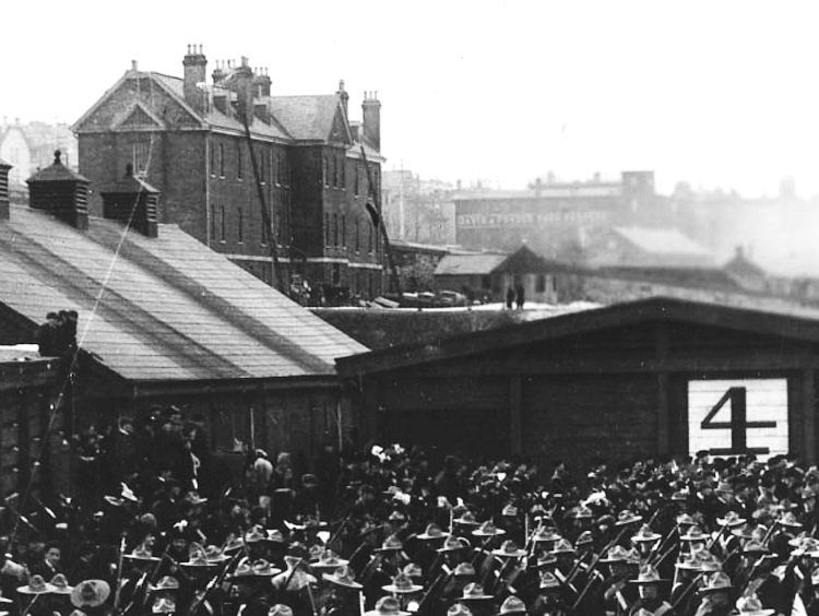
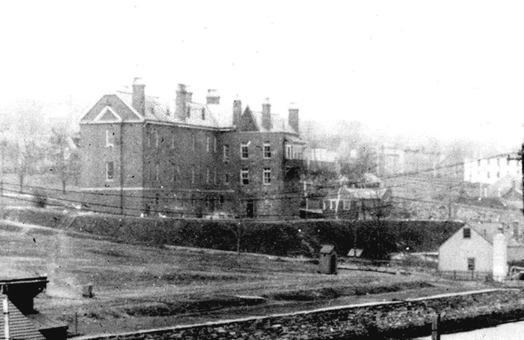
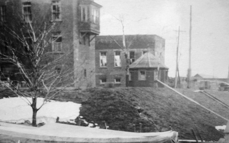
Below are three views of the Naval Hospital and smoking house. The first is from Pier 4 ca. 1899 (from Notman Studio NSARM accession no. 1983-310 number 7145). Secondly, a photo from the Niobe Collection, ca 1914. Note the addition to the middle section of the brick building that by then housed the Royal Naval College of Canada. The third photo is of the right section of a December 1918 panorama by W. G. MacLaughlan of HMCS Niobe's officers and men (MMA - M81.233.2 Crew of HMCS NIOBE, Hfx, NS). The smoking house managed to survive the Halifax Explosion.
Page 2
"Anatomy Of A Distaster" (article): Page 1 Page 2 Page 3 Page 4 Page 5 Page 6 Page 7
Faces of the Halifax Explosion Debunking the 13 Mile Myth
1) Whether the spired structure in front of the Naval Hospital was the Dockyard Observatory.
2) Whether the Dockyard Observatory existed as early as 1815.
3) The physical appearance of the observatory itself.
Conclusions:
1) The spired building is specifically designated as a smoking house on the 1890 and 1893 corrected W. A. Hendry maps.
2) The photograph of the structure ca. 1883 shows the structure as fairly well-kept with a solid appearance.
3) That the structure sat in front of the Naval Hospital strongly indicates it was not the observatory.
4) If one were to accept Edward J. Powell's (1867 & 1869) hexagon shape for the observatory, the smoking house as it appears in the ca. 1883 photograph and on the 1890 map does not match that description.
5) The building sat in front of the Naval Hospital as late as 1921 (Below: December 1918). The fact it was still present years after the documented destruction of the observatory by the Royal Engineers, plus all of the preceding factors, constitutes a preponderance of evidence that the spired structure was not the observatory.
6) The MacKenzie plan copy does not prove the observatory was present in HMC Dockyard in the year 1815. The words "true copy" or "record copy" are not present and the description states it is is Her Majesty's (Victoria) not His Majesty's (George III) careening yard. Also, the respective Reference Tables of this plan and the 1831 George Ledwell Taylor plan show buildings which were not present in 1812-1819. The plans are so similar, it raises the possibility that McKenzie's was a copy of Taylor's original work. 7) Edward J. Powell's hexagon vs. James MacKenzie's octagon remains an anomaly and puts into question the accepted appearance of the actual observatory as the latter.
8) The Dockyard Plan from 1831 shows no structures in the area formerly occupied by Fort Coote.
All in all, the distinct lack of documentation as to the origins of both buildings indicates that much more research is required.
Below are three views of the Naval Hospital and smoking house. The first is from Pier 4 ca. 1899 (from Notman Studio NSARM accession no. 1983-310 number 7145). Secondly, a photo from the Niobe Collection, ca 1914. Note the addition to the middle section of the brick building that by then housed the Royal Naval College of Canada. The third photo is of the right section of a December 1918 panorama by W. G. MacLaughlan of HMCS Niobe's officers and men (MMA - M81.233.2 Crew of HMCS NIOBE, Hfx, NS). The smoking house managed to survive the Halifax Explosion.
Page 2
"Anatomy Of A Distaster" (article): Page 1 Page 2 Page 3 Page 4 Page 5 Page 6 Page 7
Faces of the Halifax Explosion Debunking the 13 Mile Myth
| Main | Jazz Guitar | Shakespeare Sonnets | About SVP/HalifaxExplosion.net | Links | SVP News | Contact SVP |
![]() 2011-2014 SVP Productions. All text protected. All rights reserved.
2011-2014 SVP Productions. All text protected. All rights reserved.